Neighborhood Fears Water Displacement
by John DiCocco

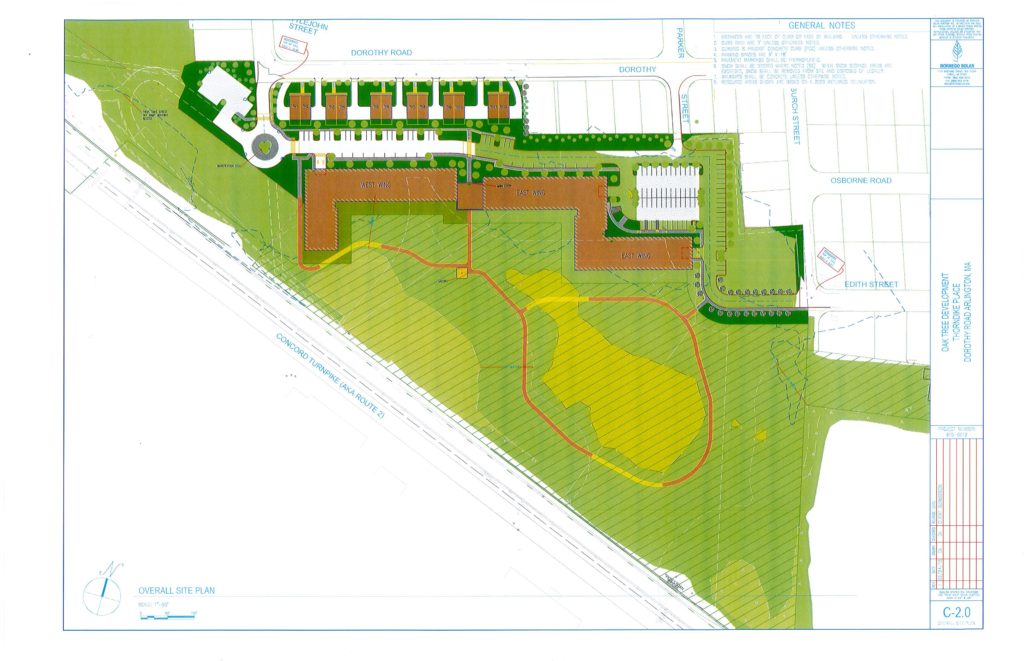
The triangular plot along Route 2 westbound where the Mugar family wants to build Thorndike Place. (Map by Oaktree.)
The Mugar Wetlands in East Arlington is a triangular parcel that borders Route 2 westbound, adjacent to the Thorndike Park playing fields, and just across Route 2 from the Vox on Two apartments and Lanes & Games Bowling. The Mugar family, owners for more than 50 years, wants to develop it with townhouses and an apartment building. Residents in the town of Arlington, led by the Coalition to Save the Mugar Wetlands (CSMW) are opposed.
In dispute is whether the land can handle the water displacement, whether the neighborhood can handle more people, and what will happen to the wildlife currently living therein.
Currently the proposal is in the hands of the state, considering an appeal by Arlington.
State Versus Town Needs
In July/August 2016 and September/October 2016, the Belmont Citizens Forum Newsletter ran articles about the state’s desire for communities to build more housing, particularly affordable housing. High housing costs and high occupancy hurt the ability of Massachusetts employers to compete for talented young employees in important sectors. Yet some cities and towns inside Route 128, including Belmont and Arlington, face particular challenges because of the scarcity of buildable space.
This state goal, together with Chapter 40B (requiring cities and towns to provide more affordable housing), puts some local communities in conflict with the state. The Mugar Wetlands is one such property in contention. (See below for explanation of Chapter 40B.)
The Mugar project, to be named Thorndike Place, would include a 50-foot building with 207 rental units, six two-family townhouses, and indoor and outdoor paved parking for about 300 vehicles. The buildings together occupy about 6.7 acres of the 17.7-acre property, most of which is in the FEMA floodplain. The property abuts Dorothy, Edith, and Burch Streets in East Arlington.
Chapter 40B: The “Affordable” Gambit
The development manager is Oaktree/Greenline LLC on behalf of Arlington Land Realty LLC, a company managed by Peter Mugar. SEB LLC, a representative of Oaktree, applied for 40B eligibility in June. The application was submitted to Arlington on August 31, 2016, and town and development officials have been wrangling about the submitted documents ever since. (The application is on the town website.)
The proposal has drawn persistent opposition from nearly all town officials as well as Arlington’s legislative delegation.
Chapter 40B requires that at least 1.5% of a municipality’s buildable land be devoted to affordable housing. Arlington calculates 1.53%. Mugar says 1.39%.
Chapter 40B requires that at least 1.5% of a municipality’s buildable land be devoted to affordable housing, in order to claim “safe harbor” from 40B. In opposing Thorndike Place in late September, the town calculated 1.53% usage already, but Oaktree calculated 1.39%, allowing room to claim 40B.
On November 18, 2016, the state Department of Housing and Community Development (DHCD) reviewed the town’s and the developer’s numbers, and found in favor of the developer’s 1.39% calculation. On November 29, Arlington appealed the state judgment to the state Housing Appeals Committee (HAC), a forum within the DHCD. The expected timeframe for their decision is four to eight months.
(See the flow chart online of the entire process on the CSMW Facebook page, saveourwetlands.)

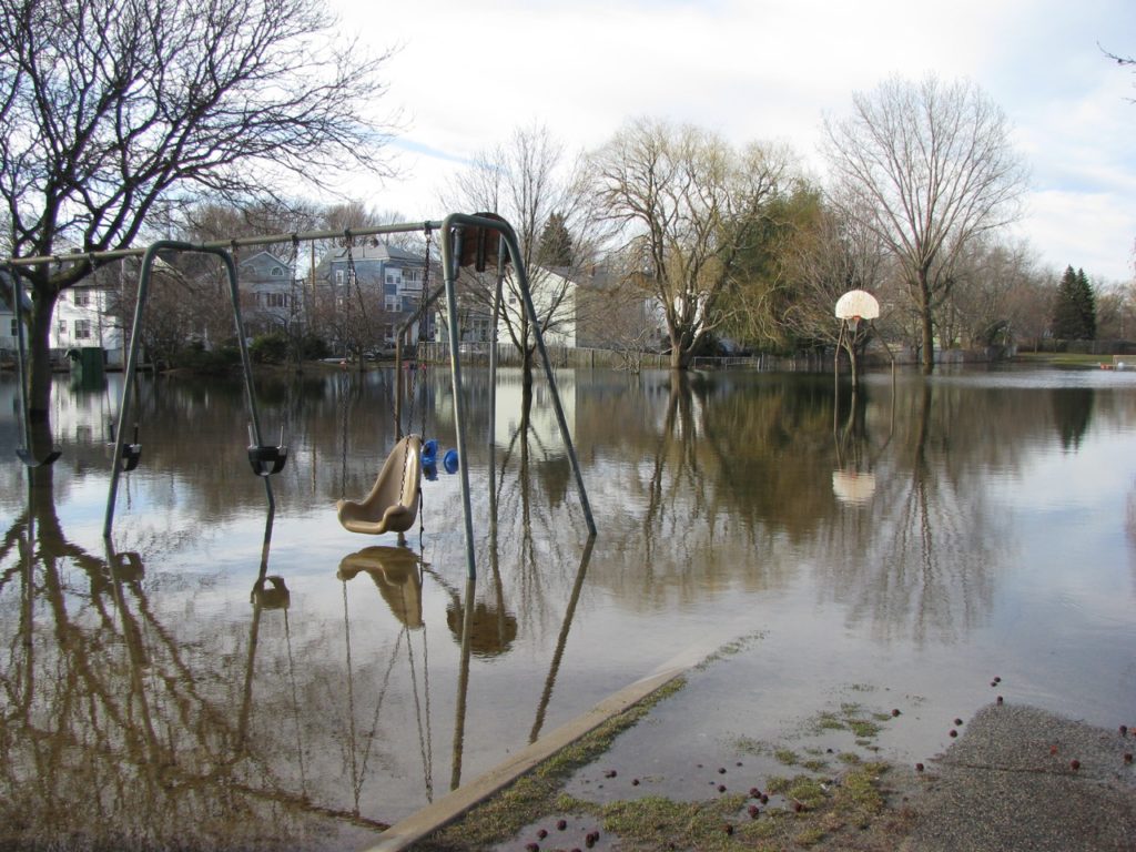
Local residents refer to Magnolia Park as“Lake Magnolia” during periods of flooding. This area is just two blocks northeast of the Thorndike Place site. (Kim Carney photo.)
The numbers don’t compute
According to CSMW member Clarissa Rowe, a landscape architect and former Arlington selectman, the process for calculating buildable land in a wetlands is complex, and some of the state language contains contradictions. “We have an outstanding [geographic information system] specialist in town who has calculated the usable land on that parcel at only 1.5 acres.* The site cannot sustain the proposed buildings on 6.7 acres without substantial water table displacement, which would go right into our neighborhood. Essentially about 5.5 of the 6.7 acres where they want to build is in the flood zone.”
The Coalition’s website says: “Flood plains act as a sponge for nearby groundwater and storm water. If the ‘sponge’ is paved over, the flood plain will no longer serve this essential purpose and the water will flood into East Arlington neighborhoods.”
Rowe says that “groundwater flow and absorption is already a big problem. However, Oaktree Development people have stated, ‘groundwater is not our purview.’”
“Since 2002, I’ve seen neighbors in a canoe—on their street—because of local flooding.”
Erin Freeburger, a CSMW member and nearby resident says, “Since 2002, I’ve seen neighbors in a canoe—on their street—because of local flooding.” The neighborhood has added homes over the last decade, she said, “and there’s really nowhere else for the water to go. Any large- scale building will affect the soccer field where hundreds of kids and adults play, as well as the bike path. All of this will be negatively affected by any more development.”
According to Freeburger, “the developer is using Chapter 40B as a loophole to avoid Arlington’s wetland and other regulations.” The developer proposes that three of the townhouses and 55 of the apartment units be designated permanently affordable (only those earning 80% or less of area median income would be eligible to purchase or rent). Everyone we interviewed for this article agreed that affordable housing was desirable, but that this piece of land could not accommodate as big a development as Mugar proposes.
What’s Next?
Should the HAC decide Arlington’s calculation is correct, the developer can nevertheless submit their application directly to the Town of Arlington where it would follow the normal review process by the various boards under local bylaws and regulations.
Should HAC confirm Oaktree’s calculation and the town lose, the developer is still expected to submit their application for local review, a process led by the Zoning Board of Appeals (ZBA) with a recommendation by the town’s Conservation Commission. However, the application would be reviewed based on adherence to state regulations instead of local regulations. CSMW says, “It is here that one can see how Oaktree is using the 40B statute to walk around Arlington’s bylaws, since the developer has applied for an exemption, including 13 waivers to local regulations, including Arlington’s wetland protection bylaw.”
“. . . Oaktree is using the 40B statute to walk around Arlington’s bylaws since the developer has applied for . . .13 waivers to local regulations.”
Zoning Board’s Three Choices
The ZBA has three choices at that point: deny the application outright, accept the application as is, or accept the applications with conditions.
If HAC approves Oaktree’s appeal as is or with mediated conditions, then the abutters would take legal action. They would have to show that specific damage, such as erosion and light or noise impacts on their property, would result from the developers bypassing the applicable zoning laws. These damages would be in addition to the flooding that will result from the development that would have been mitigated had the local wetland bylaw been followed.
Based on similar processes in other towns, a denial of the application would most likely provoke Oaktree to escalate the decision back to the HAC which has the right and has, more often than not, granted permission to the developer to build as proposed.
On the other hand, if the town accepts the application with conditions, Oaktree can accept them or show the state that the project becomes uneconomical within those conditions. Again, the HAC would be called upon to assure a plan that is economically viable for Oaktree.
At this level of appeal, HAC, more often than not, has granted the building permit, under looser conditions to the developer.

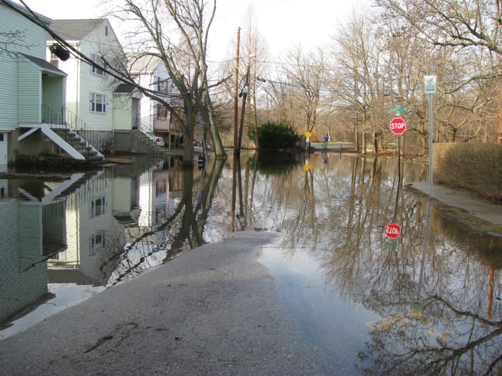
Varnum Street, above, dead-ends at the MinuteMan Bikeway (seen at the center of the photo) which itself abuts the proposed site of Thorndike Place. (Kim Carney photo.)
Where Will the Water Go?
Since all but 1.5 acres lie in the FEMA floodplain, local residents and officials believe almost any new building in that site will deflect floodwater into existing homes. “Many of us in the immediate vicinity already get water in our basements during a heavy rain,” says Griffith.
In addition, the wetlands are home to a variety of birds, foxes, and even deer. Building on this site and adding the activity of 500 humans would eliminate one of the town’s few remaining natural areas.
The CSMW’s website further states that the development is inconsistent with Arlington’s 2015 Master Plan. In 2000, 2001, and 2015, Arlington Town Meeting voted to support conservation of this site.
Traffic and Safety Concerns
There are other concerns as well, including schools and traffic. Freeburger and others feel the developer has projected lower numbers of expected residents than may actually occupy the space. “The last 20 people who have moved into our neighborhood are all families with kids moving out of cramped Boston spaces. We think that trend will continue,” Freeburger adds. The developer is projecting only about 30 school-age children, “but in the three homes on my shared driveway we have eight children alone.”
Griffith says “A lot families going to soccer practice and games park throughout the neighborhood and walk along and across the streets to get to the fields—adding all the cars going in and out of the development is a huge safety concern. It’s the same with kids walking to the Hardy School each morning. We can barely park on our own streets when the soccer field is in use, and the commute is already painful since the only outlet is Lake Street. At peak commute times, it can take 35 minutes to exit Route 2 and arrive at Mass Avenue. Adding several hundred residents will multiply those problems.”
A further objection by neighbors is that the town will have expenses related to infrastructure (electrical, water, sewage).
Belmont Citizens Forum will continue to follow the story.
John DiCocco is editor of the Belmont Citizens Forum Newsletter.
Chapter 40B and Safe Harbor Status
A safe harbor status proves that a town meets the criteria for affordable housing and any developers must go through the normal process.
The 40B program has been controversial, because a developer—a public agency, nonprofit organization, or limited-dividend company—has the right to appeal an adverse local decision to the state in communities with little affordable housing (less than 10% of its year-round housing or 1.5% of its land area).
Communities that have not yet met one of these thresholds can also receive one- or two-year exemptions from state appeals by adopting a housing production plan and meeting short-term production goals.
In July, 2011, 47 cities and towns were appeal-proof: 39 because they met the 10% goal, at least three more because they met the land area standard, and another five with two-year exemptions. Communities above the 10% housing or 1.5% buildable land threshold can still accept 40B development proposals at their choice.
The state statute often referred to as “40B” was put in place as an economic incentive for developers in the late 1960s to build housing that includes at least 20% affordable units. A permit granted by the state under 40B allows the developer to bypass local zoning, such as local wetland restoration requirements or height restrictions. State regulations are less restrictive than Arlington’s local regulations but would still be required.
At the same time, the law gives towns four different ways to show that they are providing or creating sufficient affordable housing by other means. Most commonly, towns with large areas of buildable land seek this so-called Safe Harbor status based on 10% of their total housing units earmarked as affordable.
More densely populated towns, such as Arlington, with little or no ability to build new housing can show that 1.5% of their buildable land is already dedicated toaffordable housing. Arlington is one of the densest municipalities in the state.
Jennifer Griffith, a member of CSMW, says “We pay our tax dollars to developers under 40B–so we are paying to enable them to do these huge inappropriate developments. The benefits of avoiding local regulations are not enough–the state actually gives them our tax money because they are including the affordable units.”
“There are two levels of affordability . . . Oaktree’s project is going to charge the higher 80% rents–not the truly more affordable 60%.”
She continues: “There are two levels of affordability: units for those making 60% of median income and those making 80%. Oaktree’s project is going to charge the higher 80% rents–not the truly more affordable 60%.”
Stoneham and Newton Examples
The ability to claim safe harbor by showing that 1.5% of land area is dedicated to affordable housing has not been extensively used by towns in the 45+ year history of the 40B law.
Only recently, the ZBA of Stoneham appealed to the HAC for safe harbor from one application and in a similar timeframe, the ZBA of Newton appealed to the HAC against two 40B applicants.
Both towns claimed 1.5%, however, all three cases were denied by the HAC on grounds that the included land area was underestimated while the area for affordable housing was over-counted. Stoneham has already taken its appeal into the courts, and Newton’s decision on next steps is still outstanding, according to Doug Heim, Arlington’s Town Counsel.
Towns are breaking new ground by challenging the interpretation of “buildable land.”
Towns are breaking new ground by challenging the interpretation of “buildable land.” For example, developers in Newton have included public golf courses as “buildable land.” Some developers even count cemeteries. Arlington claims to follow the legal definition. The developer is interpreting the law differently, but does not show their calculations. The guidelines for determining the calculations are confusing and, at times, contradictory.
Visit the Coalition website here.
Thorndike Place, in Their Own Words
The summary below is taken from Oaktree’s application to the ZBA. The full public document, with many illustrations and detailed documents, is available at arlingtonma.gov
“Thorndike Place is a land conservation and housing development which, as currently proposed, will provide the Town of Arlington with 219 units of housing (25% of which will be affordable) while preserving approximately 11 acres of open conservation land in perpetuity. Owned by the Mugar family for over 50 years, the 17.7-acre site sits adjacent to Thorndike Field, near Spy Pond, and is an eight-minute walk to Alewife Station in Cambridge. The transit-oriented, energy-efficient project will be comprised of 12 ownership units housed in six duplex townhouses, and 207 one-, two-, and three-bedroom rental apartments. Three of the townhouses and 55 of the apartment units will be designated as permanently affordable (only those earning 80% or less of area median income will be eligible to purchase or rent). The four-story apartment buildings would be located behind a buffer of trees and the townhouses on Dorothy Road in East Arlington.”


Sorry, the comment form is closed at this time.