By Jeff Roth
Few Belmont residents use bikes to get around this small town of only 4.7 square miles, although most live hardly a mile from schools, recreation facilities, stores, transit stations, and restaurants. About 8.2% of Cambridge residents commute regularly by bike, but Belmont’s car-centered infrastructure likely is closer to the state average of 0.9%. Given that short, local trips are responsible for 60% of automobile pollution, how can we encourage car-free travel?
Benefits of Walking and Cycling
There are many benefits to expanding cycling and walking options in Belmont. People who cycle regularly for transportation and fitness have overall health comparable to people 10 years younger. People who walk and bike are also twice as likely to shop at local businesses as car users. A readily quantifiable benefit from cycling and walking is reduced parking costs. On-street surface car parking costs the public an average of $400 per space annually. Bicycle racks are so cheap that cities would profit even if they paid $5 to each person parking a bike there.
Accommodating bicycles is cheaper and easier to fit into compactly developed areas like Belmont than adding car spaces. The only way to provide new transportation capacity affordably in small communities like ours is to create safe and connected cycling and walking infrastructure, at least for those physically capable of cycling or walking some distance.
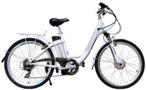
Electric bicycles are growing in popularity because they’ve gotten cheaper. Unlike mopeds and motorcycles, e-bikes can’t go faster than an unassisted rider on a regular bike, and e-bikes also replace substantially more car trips at a more substantial rate than regular bicycles. E-bikes make up more than 10% of sales at Belmont Wheelworks, the top bicycle store in Massachusetts.
Trends show people want to bike to more places. In 2013, a Belmont Community Path Advisory Committee (CPAC) survey reported that 89% of residents were in favor of an off-road community path in town for cycling and walking. During the COVID-19 pandemic, trail use in the United States tripled: cycling and walking proved to be popular outdoor activities conducive to social distancing.
Traffic calming policy
Traffic calming reduces vehicle speeds and increases driver attentiveness, making streets and neighborhoods safer and more appealing, and improving safety for motor vehicles, pedestrians and bicyclists. The theory behind traffic calming is that building or retrofitting roadways with certain features induces drivers to slow down and pay closer attention to their surroundings.
Belmont adopted a traffic-calming policy in 2020 that is designed to address concerns about traffic safety such as cut-through traffic and high motor-vehicle speeds.
Residents can initiate a request for their neighborhoods by filling out the Traffic Calming Request Form online, available at the end of the Traffic Calming Policy at www.belmont-ma.gov/transportation-advisory-committee. The town staff will evaluate the request. If it meets eligibility requirements, the Transportation Advisory Committee (TAC) holds a public meeting to discuss the needs assessment and possible traffic-calming measures, and then may recommend measures to the Select Board, which has the final say.
In the lead-up to the pandemic, the TAC received three traffic-calming requests:
- Residents on Village Hill Road requested restrictions for cut-through car traffic.
- Rutledge Road residents also asked for cut-through traffic restrictions.
- Residents on Somerset Street and Wellington Lane asked for traffic calming to address car-traffic volume and speed as a way to reduce cut-through traffic.
Once traffic data were collected, Village Hill Road and Rutledge Road requests met the eligibility criteria based on car volume and speed data. Turn-restriction signs for car traffic were recommended for installation after the pandemic ends.
The Somerset Street and Wellington Lane request is still under consideration pending further traffic studies.
The town has since received many more traffic calming requests. These will likely be addressed in the fall when traffic may have returned to pre-pandemic levels, and traffic studies can document the full burden of traffic on streets.
Winter/Concord/Mill roundabouts
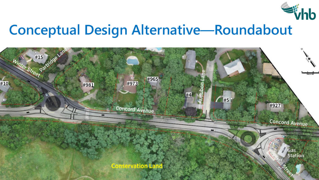
Long-standing safety and congestion issues have persisted around the intersections of Winter Street, Concord Avenue, and Mill Street. The town hired the consulting firm VHB which presented potential redesigns to the Belmont Traffic Advisory Committee (the former iteration of the current TAC) in 2017. The current conceptional design under discussion by the TAC and Belmont residents was updated by VHB in 2021.
The TAC convened a public meeting in January on this draft design which includes a pair of roundabouts in the area. The design could include a 10-foot wide, shared use path extending between the two roundabouts for walking and cycling. The design also could incorporate sidewalks on the north side between Concord Avenue and Winter Street to improve connections to the Rock Meadow trail system.
Construction funding is the major challenge for this plan. The town wishes to apply for a MassWorks grant funding. However, to qualify for MassWorks funding, a project needs to be ready for construction within the current fiscal year, which is unlikely.
The project also calls for reducing cut-through traffic on Partridge Lane by closing it to through-car traffic while still admitting pedestrians and bicyclists. The residents expressed general support for this concept.
After the town gathers the necessary information for further consideration and development of the plan, the TAC will hold another public meeting to discuss the concept as it appears overlaid on the map.
Concord Avenue Re-striping Proposal
The TAC has been discussing parking-protected bicycle lanes on the eastern segments of Concord Avenue from Leonard Street to the Cambridge border. This concept originated with and has been endorsed by both the High School Traffic Working Group and the Belmont Middle/High School Building Committee.
Protected bicycle lanes (PBLs) lower crash rates by a factor of two to 23 times. Locations with high cycling usage, as in Cambridge, often rely on PBLs. “Dooring” crashes, which account for 20% of bike/car crashes, disappear almost completely with PBLs.
Belmonters’ great enthusiasm for the PBL is understandable: it allows easy access to the new school building as well as Cambridge’s extensive network of bike lanes. Other residents are excited that the plan’s traffic calming on Concord Avenue will result in slower and more attentive driving, thus increasing safety for all concerned. However, some residents and business owners have voiced concern about the proposal. Discussions are continuing on this topic.
Parking with bicycle lanes
When bicycle lanes were painted in Belmont Center a few years ago, the lanes were placed to the left of the metered, on-street parking spaces on Leonard Street.
Because cyclists are a minority, the more signs and symbols that train drivers to look for cyclists, the better and safer the roads become.
Bicycle lanes usually have a solid white line separating travel lanes from bicycle lanes, but there is no set standard for marking off bicycle lanes from on-street parking lanes. In Belmont Center, discontinuous “T” lines were used, which made it hard for drivers to see the edge of the bicycle lane when parking. Cars could block the bicycle lanes and make them less safe.
In 2019, TAC made a recommendation to follow the National Association of City Transportation Officials standard and paint solid lines between bicycle lanes and on-street parking spaces. This simple approach could be adopted in other areas with bicycle lanes such as Trapelo Road through Waverley Square.
Shared-lane markings (sharrows)
Other appealing features of cycling improvements include their low cost and simplicity. Shared-lane markings, or “sharrows,” are painted bike markings on streets where there is no room for a formal bicycle lane. Belmont first painted sharrows in 2018, on Concord Avenue, Lexington Street, Winter Street, and Brighton Street. Sections of Concord Avenue were repainted this spring, and there are plans to repaint the rest of these roads this year.
While sharrows don’t alter a road, they raise drivers’ (and pedestrians’) awareness of cyclists. Because cyclists are a minority, the more signs and symbols that train drivers to look for cyclists, the better and safer the roads become. Studies show that cyclists are slightly safer when there are sharrows on roads, although the real benefits come from reducing conflicts between bicycles and moving and/or parked cars. Sharrows often work in conjunction with “Bikes May Use Full Lane” (BMUFL) signs, first installed in Belmont in 2016.
A common misconception is that cyclists have fewer rights than drivers. However, cyclists often need to use the full lane when there are obstructions, parked cars, potholes, or no shoulder space. While Massachusetts law clearly states that cyclists (like cars) have the right-of-way over traffic behind them, the BMUFL signs help reinforce the law for motorists who might not be aware of it.
TAC meeting schedule
TAC meetings are on Thursday evenings at 7PM monthly or bimonthly, and agendas are posted on the town website at www.belmont-ma.gov/transportation-advisory-committee.
References
People For Bikes, “Where We Ride”
- Elly Blue, Bikenomics
- Donald Shoup, The High Cost of Free Parking
- 2014 Belmont CPAC Final Report
- RTC 2020 Trail counts Report
- Lusk & Morency, AJPH, 2013.
- Toole Report, City of Cambridge, 2014
- NACTO Urban Bikeway Design Guide, page 12, 2nd Edition, 2014.
Jeffrey Roth has lived in Belmont since 2009. He was chair of the Belmont Community Path Advisory Committee from 2011 to 2014, and he has been a member of the Belmont Transportation Advisory Committee since 2019.


Sorry, the comment form is closed at this time.