By Julia Hopkins and Julie Wood
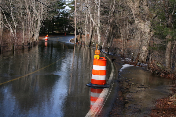
Climate change isn’t coming—it’s here. Sea-level rise, drought, blistering heat; the tangible effects of global warming are already happening in Massachusetts, and our highly urbanized watershed and those who call it home are increasingly vulnerable to its impacts. It also means extreme weather and severe inland flooding are some of the greatest threats to our watershed and our lives.
In the northeastern United States, precipitation during heavy rain events increased by more than 70% according to the Fourth National Climate Assessment released in 2018. This trend is expected to continue as our climate warms. Today’s 25-year rain event is predicted to become a 10-year rainfall event in 2070. Today’s 100-year rain event is predicted to become a 25-year rain event in 2070.
What is a 25-year rain event?
Planners talk about 10-year, 25-year, even 100-year rain events as shorthand for how likely it is to have a storm that big any given year. A 10-year rain event has a 10% chance of happening this year; a 25-year rain event, 4%; a 100-year rain event, 1%.
What does this mean for the Charles River, which drains about a third of Belmont’s land? (See “CRWA Works to Keep the Charles River Clean,” Belmont Citizens Forum Newsletter, November/December 2021). More flooding. A few inches of increase in rainfall across the watershed has the potential to increase the Charles River’s volume by millions of gallons during a heavy storm. Our aging stormwater infrastructure can still withstand today’s rainfall patterns (for example, it may be designed for today’s 25-year storms), but it will not be able to handle future heavy precipitation events, causing even greater flood risks.
A watershed-wide collaboration
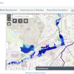
That’s where the Charles River Flood Model comes in. A first-of-its-kind watershed-scale flood visualization, this model is a vital tool that will help our watershed prepare for extreme weather and inland flooding. Its unique power is its regional scale and ability to encourage communities in the watershed to collaborate and share resources to collectively prepare for this growing threat.
The Charles River Flood Model visualizes the impacts of various storm events, including current and projected future storms. The model can also test adaptation and mitigation strategies that protect homes, critical infrastructure, and livelihoods. The model can help quantify the potential results of flood mitigation strategies, providing communities with a level of confidence in the potential impact of their investment.
The Charles River Flood Model was created in partnership with the Charles River Climate Compact, established by the Charles River Watershed Association (CRWA) in 2019. This group of 21 municipalities is working together to build regional climate resilience A subgroup of these communities—including Arlington, Dedham, Franklin, Holliston, Medway, Millis, Natick, Needham, Newton, Norfolk, Sherborn, Watertown, Wellesley, Weston, and Wrentham —partnered to obtain funding from the MA Executive Office of Energy and Environmental Affairs (Mass EEA) and the Municipal Vulnerability Preparedness (MVP) Action Grant Program to develop the model. Weston & Sampson was the technical lead on the project. The model is a critical step in helping our communities protect vulnerable populations and property from flooding by predicting where and when flooding will occur and recommending adaptation and mitigation strategies.
Developing the model began at the ground level, creating a network of features that move water across the region including streams, culverts, stormwater pipes, manholes, and catch basins. The model is overlaid with two-dimensional cells to depict where floodwaters may go, accounting for how quickly stormwater runoff may reach a stream.
In highly urbanized areas with large areas of impervious cover, stormwater flows off roofs, parking lots, and roadways directly and quickly into the river, increasing flood risks for downstream areas. In contrast, in low density, relatively undeveloped areas with protected wetlands, mature trees, and open space, a higher proportion of rainwater is absorbed into the ground rather than directed into storm drains, mitigating heavy precipitation and reducing flood risk. The Charles River Flood Model was developed at the watershed scale which recognizes that cities and towns are interconnected, as highly developed areas upstream affect the rest of the watershed and its ability to weather an extreme storm.
Flood predictions, flood solutions
The Charles River Flood Model found that without intervention, in 2070 a projected 100-year storm will impact more than 50 critical facilities such as schools, medical offices, police stations, and water supply wells, and flood up to 12,500 acres of land within the watershed. This exceeds the estimated 10,400 acres of flooding during the severe rains of March 2010, which caused a state of emergency, widespread evacuations, public transit shutdowns, and resulted in considerable damage to homes, businesses, and municipal buildings.
The Charles River Flood Model also shows the flood mitigation benefits of nature-based solutions such as land conservation, green stormwater infrastructure, and/or reducing impervious surfaces. However, bold action and significant investment will be required to mitigate projected flooding at present-day levels. Initial modeling found that none of the nature-based solutions investigated were enough to mitigate the future impacts of climate change. The heavily developed watershed is already susceptible to damage from present-day storms, and climate change will exacerbate flooding, heightening the need for bigger, more aggressive measures to keep our communities above water.
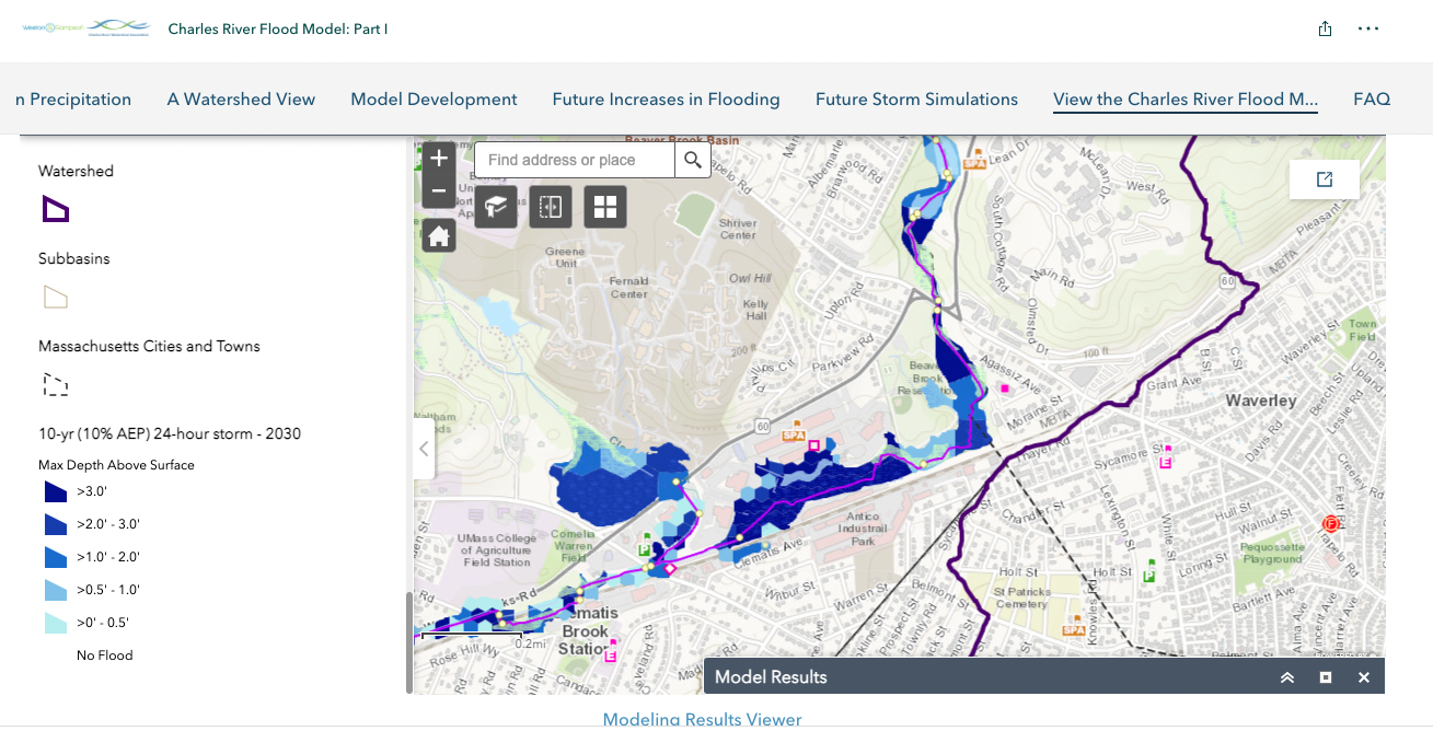
The Charles River Flood Model’s predictions for a 10-year rain event in Belmont in 2030. Shades indicate water depth: the darkest areas on this map correspond to flood waters three feet or deeper. For more information, see crwa.org/watershed-model.html.
One of the nature-based solution scenarios investigated in the Charles River Flood Model tests the impact of developing unprotected land vulnerable to future development. Developing just half of the watershed’s remaining undeveloped and unprotected land without incorporating flood control measures would result in a 33% increase in flooded area in a present-day 10-year storm, and another 20% increase in flooded area in a 10-year storm in 2070. Allowing development without aggressive flood protection will cause downstream flooding and directly impact vulnerable residents.
“Modeling results demonstrate the need to work together as a region, and show there may be areas of the watershed that it makes sense to leave undeveloped while encouraging greater density in other areas,” said Emily Norton, CRWA’s executive director.
In September, the Baker-Polito administration awarded $233,000 to CRWA and 19 Charles River watershed communities for Building Resilience Across the Charles River Watershed Phase II,, which will result in the development of a regional Adaptation Implementation Plan for freshwater flooding. The plan will include the design of up to four site-specific flood mitigation projects within the Charles River watershed.
“This additional funding will allow us to help cities and towns take bold action to reduce the dangerous flooding already happening, and prepare for the even more intense rainstorms of the future,” said Norton. “The Charles River Flood Model clearly demonstrates the impacts coming to our region, but it allows us to test out the benefits of potential flood mitigation strategies so we know we are making sound investments.”
In addition, the plan will include policy tools and resources to support each municipality in implementing additional strategies that the model demonstrates to be effective, such as reducing impervious cover and increasing green stormwater infrastructure. These efforts will help bring nature-based solutions for flood mitigation into the mainstream and give communities the tools they need to advocate for these solutions.
Julia Hopkins is communications and outreach manager for the Charles River Watershed Association. Julie Wood is deputy director of the Charles River Watershed Association.

Sorry, the comment form is closed at this time.