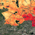
Detail of a map of surface temperatures recorded by Wicked Hot Mystic, a collaborative project of the Museum of Science, Boston, in partnership with the Resilient Mystic River Collaborative (RMC), Mystic River Watershed Association, and the Metropolitan Area Planning Council. On August 12 and 13, 2021, over 80 volunteers joined MOS and MyRWA in measuring ground-level air temperature, humidity, and air particulate matter using special sensors mounted on cars and bikes. This data was collected August 12 at 3 pm. Note that the McLean conservation land is 10F cooler than surrounding areas. For more information see www.mos.org/explore/public-events/wicked-hot-mystic


